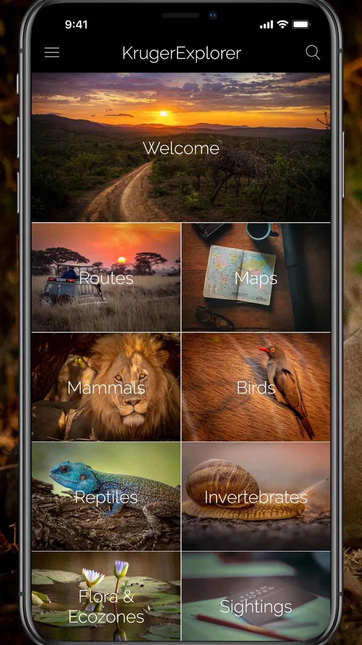
KrugerExplorer
- 5.0
- Rating
- 10.00K
- Installs
- $12.99
- Price

 Analysis by App-foxy
Planning a visit to Kruger National Park can quickly become a juggling act between maps, wildlife references, route ideas, and a reliable sense of where everything fits together. KrugerExplorer takes a more focused approach: it is a paid Travel & Local app from Explorer Apps built around the park itself, rather than a general travel planner trying to cover every destination. After spending time with it, I see its main value in preparation and orientation. It gives a trip a stronger sense of place before you arrive, and it remains useful when you want to connect a possible route with the animals and landscapes you may encounter.
The app is aimed at people who want more than a broad map pin and a list of tourist attractions. Its subject is specifically Kruger National Park, with wildlife, routes, and maps brought together in one reference. That combination makes it especially appealing to first-time visitors, wildlife enthusiasts, photographers, and anyone who prefers to understand a destination before making decisions on the ground.
It is not a replacement for every travel tool. I would not treat it as my only source for live travel conditions, reservations, emergency information, or general South Africa planning. Instead, I found it most effective as a dedicated park companion: something to explore at home, consult during a quiet moment, and use to make a day in Kruger feel less improvised.
You May Also Like

 Pandora - Music & Podcasts
Pandora’s Music Is Easy to Start, but Harder to Recover
Pandora’s strength is its low-effort path from a seed to a station. Its weak spot is how much confidence it asks you to place in connection, setup, and quiet recovery.

 AccuWeather: Weather Radar
AccuWeather Review: A Quick, Clear Forecast for Everyday Decisions
For everyday plans, the best forecast is the one you can understand quickly. AccuWeather makes rain timing, radar, and local conditions easy to act on, with a few trade-offs.

 Hill Climb Racing
Why Hill Climb Racing Still Turns Crashes Into One More Run
A tiny car, a bumpy hill and one more upgrade: Hill Climb Racing keeps resurfacing because its simple chaos makes every near-miss feel personal.

 AliExpress - Shopping App
AliExpress Makes Global Shopping Feel Personal, but Shoppers Bear the Risk
AliExpress turns a global marketplace into a pocket-sized discovery engine. Its reach is useful, its shopping loop compelling, and its trade-offs easy to miss.

 Lords Mobile: Kingdom Wars
Lords Mobile Is a Kingdom-Building Routine, Not a Quick Match
A case-by-case verdict on the building, battles, device demands, and social commitments that make Lords Mobile rewarding for some players and exhausting for others.

 PDF Scanner app - TapScanner
TapScanner Makes Paperwork Easier to Capture, Check, and Share
TapScanner makes scanning with a phone feel less like a rescue operation and more like a dependable step in getting work done. Its capture tools are useful, though not flawless.
More From Our News Desk
View All News


How I used KrugerExplorer to build a practical park routine
I use KrugerExplorer to turn a broad interest in Kruger into a routine that stays manageable: learn a little about the wildlife, compare possible routes, then check the map before settling on a direction. That order helps me avoid overplanning and gives travel companions a clear reason for the day’s choice. I also keep a short list of alternatives outside the app, so the next section can focus on what to check before relying on it.
Starting with the park rather than a generic travel search
My preferred starting point was to open the app with a simple question: what do I want from a day in Kruger? That sounds obvious, but it changes how the material becomes useful. A visitor interested in big cats will approach the wildlife information differently from someone mainly concerned with scenic drives, family-friendly pacing, or learning the park’s layout. Because the app is concentrated on one destination, it encourages that kind of specific planning instead of sending me through unrelated hotel, restaurant, and flight results.
I found it helpful to browse the wildlife material before looking too closely at routes. That order gives context to the map. Rather than seeing roads as lines to follow, I started thinking about them as possible habitats, viewing opportunities, and sections of a larger park experience. The app cannot turn wildlife into a predictable schedule, and it should not be used that way, but it can make route choices more informed and more interesting.
For a first visit, I would spend one session simply becoming familiar with the park’s geography. I would then return to the route and map material with a rough plan for each day. This two-pass approach is more useful than trying to make a perfect itinerary immediately. The first pass builds orientation; the second helps narrow down realistic options.
A realistic morning-before-the-drive scenario
Imagine arriving at your accommodation before an early drive. You have limited time, several possible roads, and a family or travel companion who does not want a complicated debate before sunrise. I would use KrugerExplorer the previous evening to compare the areas I am considering, review the relevant wildlife information, and agree on a broad direction. In the morning, the app’s value is not in promising a sighting. It is in helping everyone understand why that direction was chosen.
That distinction matters. Wildlife viewing depends on chance, patience, weather, traffic, and the behavior of animals. A good park reference should improve awareness without pretending to provide certainty. I appreciated the app more when I treated it as a decision aid and learning tool, not as a guarantee of what would appear around the next bend.
A useful habit is to choose one main route and one flexible alternative before setting out. The main route gives the day structure, while the alternative prevents a disappointing road condition, a tired passenger, or a change in timing from ruining the plan. The app supports this kind of thinking because its content connects maps and routes with the park’s natural attractions rather than isolating them into separate travel categories.
What the dedicated format does better than general alternatives
A standard map application is usually better for live navigation, traffic information, addresses, and getting from an airport or town to a specific entrance. A broad travel guide may be better for accommodation, restaurants, visas, and regional sightseeing. KrugerExplorer has a narrower job, and that narrowness is its advantage. It keeps attention on the park’s internal geography and wildlife instead of surrounding the destination with information I may not need during a game drive.
That focus also makes it more suitable for slow browsing. I can explore the park as a subject, not just search for a point on a map. For someone who enjoys learning about a destination before visiting, that is a meaningful difference. The trade-off is equally clear: if I need turn-by-turn navigation or a complete trip organizer, I would use another tool alongside it.
Checking the basics before relying on it
The app is listed for Everyone, which makes it easy to recommend as a shared reference for a couple or family. Its current version is 2.2.0, and it runs on Android starting with version 7.0. That broad compatibility is useful if a travel companion has an older device, although I would still install and test it before the trip rather than waiting until departure day.
KrugerExplorer costs $12.99, so the decision is different from downloading a free general map. I think the price makes the most sense for someone who is genuinely planning a Kruger visit or has a strong interest in the park. If you only want a quick look at a few attractions, free web pages and a general map may be enough. If you expect to return to the app throughout planning and during the trip, its specialization becomes easier to justify.
Settings and preparation habits worth checking
I would begin by checking the app’s basic behavior on the device I intend to carry. Make sure the text is comfortable to read, confirm that the map view is easy to interpret, and explore the wildlife and route sections before leaving home. These are simple steps, but they prevent a common travel mistake: discovering the most useful part of an app only after connectivity, battery, or time has become a problem.
I would also keep the app’s role clear beside any other navigation tool. A dedicated park encyclopedia and a live navigation service answer different questions. One helps me understand the destination; the other may help me move through a wider journey. Keeping both available avoids forcing KrugerExplorer to do work it was not designed to do.
Another worthwhile setting is the device itself. I would adjust screen brightness for daylight, avoid leaving the display active unnecessarily, and carry a charging solution suitable for a long day away from a room or vehicle power source. Those are not special functions inside the app, but they affect how practical any map-based travel reference becomes.
Making the maps easier to use in real planning
Maps are most helpful when I use them before making a decision, not while rushing through several choices. I would zoom in and out deliberately, first looking at the overall relationship between areas and then examining the route that interests me. This prevents the common error of mistaking a visually short distance for a quick drive. A park road can be part of a much longer day once stops, wildlife viewing, and changing pace are included.
I also recommend separating “where I want to go” from “how long I can comfortably spend getting there.” The map can help identify a direction, but it does not remove the need for sensible pacing. For families, older travelers, or photographers who prefer long stops, a shorter route with more flexibility may be better than covering a large section of the park.
Repeatable patterns that make the app faster to use
Experienced use is less about tapping quickly and more about repeating a good planning sequence. My preferred pattern is wildlife first, route second, map third, and practical decision last. I begin by choosing the kind of experience I want, look at routes that fit it, use the map to understand the shape of the day, and then reduce the plan to something realistic.
This sequence avoids a common trap: selecting a road because it looks attractive on the map and only later asking whether it matches the group’s interests. Starting with the purpose of the outing produces better choices. It also makes the app feel less like a collection of reference pages and more like a planning conversation.
A second useful pattern is to create a small shortlist mentally rather than trying to remember everything. I might identify two wildlife topics, two route possibilities, and one broad map area for later discussion. The point is not to invent a formal saved itinerary if the app does not provide one; it is to reduce browsing into a manageable set of decisions. I would note those choices separately if I needed a durable record.
For repeat visits, I would use the app to vary the questions I ask. On one trip, I might focus on understanding routes. On another, I could use the wildlife material to deepen my knowledge of species I did not notice previously. This keeps the app useful beyond a single planning session and avoids treating it as a one-time checklist.
Using it with travel companions
KrugerExplorer works particularly well as a shared reference when people have different expectations. One person can explore the wildlife information, another can examine routes, and both can use the map to discuss what is practical. That is more constructive than relying on one traveler’s memory or allowing the most confident voice to choose the day.
With children, I would use the wildlife content as preparation rather than turning the drive into a test. Pick a few animals or habitats to learn about, then let the actual sightings remain unpredictable. This approach gives younger travelers something to look forward to without creating disappointment when nature does not follow the plan.
For photographers, the app is useful for building a broad subject-based plan, but I would avoid treating it as a promise of photographic results. The best workflow is to use it for orientation and learning, then leave room for light, patience, and unexpected sightings to shape the day.
Advanced limits that should shape expectations
The biggest limitation is the difference between reference information and live field intelligence. A map and wildlife encyclopedia can help me understand Kruger, but they cannot replace current local guidance, official notices, road updates, opening information, or responsible advice from park staff. Before traveling, I would check official sources for practical conditions and use this app as a companion rather than an authority on changing circumstances.
I would also avoid assuming that a route reference equals navigation. If I need precise live positioning, traffic awareness, or broader directions outside the park, a conventional navigation app is the better choice. KrugerExplorer’s strength is interpretation and destination knowledge, not being the only digital tool in the vehicle.
The paid model is another genuine consideration. At $12.99, it asks for a deliberate purchase, especially from someone who may visit Kruger only once. I would recommend it to a committed visitor who values a dedicated reference, but not automatically to a casual traveler who merely wants a general overview. The app’s value grows with preparation time and interest in the park’s wildlife and routes.
There is also a human limitation: too much planning can make a wildlife trip feel overly controlled. I would use the app to create options, not to fill every hour. Leave room for a slow stop, a change of direction, or a sighting that was not part of the original idea. The best use of a detailed reference is often to make me more flexible, not more rigid.
Who should choose it, and who should skip it
I think KrugerExplorer is a strong match for first-time Kruger visitors who want a single, focused place to study the park before arrival. It is also well suited to wildlife learners, photographers, families preparing children for the trip, and returning visitors who want to refresh their understanding of routes and species. Its average rating is 5.0 from around 633 ratings, and its install base is over 10 thousand, which suggests a small but very positive audience around this focused use case.
I would be more cautious recommending it to someone who is not visiting Kruger, needs a complete South Africa itinerary, or expects free navigation with constantly changing road information. A general map, official park resources, or a broader travel guide may serve those needs better. The app is not weakened by being specialized; it simply means the buyer should have a specific reason to want a Kruger-focused reference.
Its release date of Jul 12, 2019 also helps frame the purchase. I would install the current version and examine how it behaves on my device before travel, while still checking current official information for anything time-sensitive. The app can support understanding and planning, but responsible travel decisions should not depend on a static reference alone.
My verdict after building a repeatable workflow
What I like most about KrugerExplorer is its sense of focus. It does not try to become a universal travel assistant. Instead, it brings together the parts of a Kruger visit that are easiest to separate accidentally: the animals I hope to understand, the routes I may consider, and the map that gives those choices a physical shape. That makes it more useful than a generic search when my goal is to prepare for the park itself.
I would buy it when Kruger is a real destination on my itinerary, not merely a vague possibility. I would install it early, explore the wildlife material before choosing routes, compare broad options on the maps, and keep a general navigation tool and official information available for practical details. That workflow gets the most from the app without asking it to provide live services it is not meant to replace.
My recommendation is positive, with one clear condition: choose KrugerExplorer for informed park preparation, not as your entire travel system. At its $12.99 price, it is a specialized purchase, but the specialization is exactly why it can be valuable. If you want to approach Kruger with better context, more thoughtful route choices, and a stronger understanding of the wildlife around you, I would recommend giving it a place in your travel kit.
FAQs for KrugerExplorer
01What is KrugerExplorer and what can I use it for?
KrugerExplorer is designed to help visitors plan and enjoy a trip to Kruger National Park. The app can be useful for discovering park information, preparing an itinerary, learning about wildlife and attractions, and organizing a safari experience. It is best viewed as a practical travel companion rather than a replacement for official park rules, local guides, or emergency services.
02Does KrugerExplorer work without an internet connection?
Offline availability may depend on the specific feature and the version installed on your device. Some travel information may remain accessible after it has loaded, while live updates, online maps, location services, bookings, or multimedia content may require mobile data or Wi-Fi. Before entering the park, download or save essential information and do not rely exclusively on the app in areas with limited reception.
03Can KrugerExplorer help me find animals or plan a safari route?
KrugerExplorer may provide information that helps visitors understand the park, identify points of interest, and prepare routes or activities. However, wildlife sightings are never guaranteed, and the app should not be treated as a real-time animal tracker unless that function is clearly stated in its current description. Always follow speed limits, stay inside permitted areas, and respect park safety instructions.
04Is KrugerExplorer suitable for first-time visitors to Kruger National Park?
Yes, the app can be helpful for first-time visitors because it brings travel information and park-related guidance together in a more accessible format. It may assist with preparation, orientation, and learning what to expect during a visit. Nevertheless, users should also check official park information for entrance requirements, opening times, accommodation, road conditions, conservation rules, and any temporary closures.
05Is KrugerExplorer free, and what permissions does it require?
The download price and available in-app features can vary between Android and iOS, as well as across different app versions. Review the store listing carefully for subscriptions, optional purchases, or advertising before installing. The app may request permissions such as location, storage, notifications, or network access; grant only those that are necessary for the features you intend to use.
Pros
- Offline maps help you navigate where mobile coverage is limited.
- Detailed route information supports planning before heading outdoors.
- Useful for exploring parks
- trails
- and natural areas independently.
- Location tools make it easier to identify nearby points of interest.
- Can encourage safer
- more organized outdoor trips.
Cons
- Map coverage and detail may vary significantly by region.
- Some features may require downloads before going offline.
- GPS use can drain your phone battery during long excursions.
- Trail information may not always reflect recent route changes.
- The interface may feel less intuitive for first-time users.

KrugerExplorer
Gallery